|
ASPROM | |||||||||||||||||||
The Association for the Study and Preservation of Roman Mosaics |
||||||||||||||||||||
| About ASPROM | News & Events | Publications | Mosaics in Britain | Resources | Join ASPROM | |||||||||||||||
What was it like in Britain when the Romans came along and decided to set up a new town? One of the best towns to answer this question is Wroxeter, and for two reasons. Firstly, Wroxeter is today in the open fields, for the centre of occupation has long shifted to Shrewsbury, 5 miles to the west. And secondly, unlike the south and east of Britain, the north-western Midlands were not exposed to Roman trade or influence before the conquest, so there was no move towards the creation of oppida, so it is assumed that the population lived largely in the numerous hillforts of the region, and probably also in the many lowland enclosures known in the area. Given this background, when the new Roman town of Wroxeter was imposed in the landscape, the impact of Romanisation must have been particularly stark.
In the past, there have been extensive excavations in the centre, recently around the Old Work, the large piece of Roman wall that originally separated the baths from its exercise hall. But what about the rest of the town? And what impact did it have on its surroundings? To answer these questions, a team co-ordinated by Birmingham University has been working for the past four years to trace the changes wrought by Romanisation in the landscape.
Three pieces of work provided a starting-point for this investigation. First, the major excavations carried out by Graham Webster in the baths (CA 107) and Phillip Barker on the exercise hall (CA 39) have both now been written up. Phillip Barker's work demonstrated that occupation in the ruins of the exercise hall continued well down into the fifth century, contradicting previous views. Both reports demonstrated that Wroxeter was both rich and long-lived: where then did the city's wealth come from? and why was urban life so tenacious here?
And then, secondly, there was the question of its origins. In his book The Emerging Past, Rowan Whimster summarised his work at the Royal Commission on the analysis of air photographs. These highlighted the large number of enclosures known around Wroxeter and within the upper Severn Valley generally. These sites were mostly undated, although it was thought that they belonged to the Iron Age or Roman period. How did such sites relate to the Roman city?
Thirdly, the construction of the Shrewsbury A5 by-pass provided an opportunity to investigate those enclosure sites which would be damaged or destroyed by the new road's construction, the work being carried out by Birmingham University's Field Archaeological Unit (BUFAU). The results showed a complex pattern of settlement. Two sites in particular demonstrated unexpected evidence for strong Romanisation around Wroxeter. The largest was at Meole Brace, at the edge of Shrewsbury, where an extensive roadside settlement was uncovered, with evidence for trading of amphorae and mortaria. At Duncote Farm, one mile north of Wroxeter, a complex sequence of occupation was unravelled comprising an Iron Age field system which was replaced in the mid-second century with a much more regular patter of small fields set within a gridwork of iugera-sized plots. These perhaps represent market gardens which were later levelled, the site then becoming a sub-divided rectangular enclosure with evidence of industrial activity. How extensive was this Romanisation of the countryside?
A research agenda was set up at Birmingham University: Simon Buteux, Vince Gaffney and Roger White of BUFAU drew up a programme to examine the Romanisation of Wroxeter's hinterland. Funding was provided initially by the Leverhulme Research Trust and more recently by English Heritage. From the start it was realised that the only way to deal with the complex data was by means of a powerful computer software system, specifically a Geographical Information System (GIS). This system can cope with a wide range of data provided it has a grid reference, including both point data, such as the find-spots of artefacts, and area data such as soil maps, solid and drift geology. It can also incorporate geophysical and aerial data easily. By combining all of this information, GIS is able to ask, and answer, extremely complex questions about human settlement and their relation to the landscape. It can even predict the location of sites similar to those already identified. For example, it can take known sites such as villas, assess their location, aspect, elevation, soil, and geological background, and distance to water and roads, and then search for similar locations within the study area. Those suggested sites can then be systematically investigated on the ground.
The GIS programme began by purchasing from the Ordnance Survey the geographical information for 3 blocks around Wroxeter, each 20 kilometres square, for around £50 each. This consisted of a series of numbers, each representing a spot height averaged out over a fifty metre square. These could be fed into a computer and a digital terrain model of the whole area could be produced. The Sites and Monuments Record was then added, and all the available geological data both drift and solid, all the soil maps and land use surveys, and details of the extensive National Trust estate around Attingham Park.
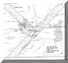 |
| This map shows the GIS study area and the three transects where field-walking took place. It also shows the position of the recent work at Duncote Farm and Whitley Grange. |
However, nearly all this data was randomly derived: records are produced only through the chance reporting of finds or by seeing sites from the air. For GIS to work effectively, more systematic collection of data was needed, the aim being to ascertain the general level of settlement in the area. To supply this new data, a number of approaches were adopted, both traditional and more modern. Amongst the traditional methods, field-walking and small-scale excavation have been the most widely used, but parish surveys and the logging of metal-detected finds have also proved useful. From the first, it was decided that the project should have a high public profile and involve as many local people as possible. Nearly 400 volunteers offered their help and of these about 150 are active field-walkers. Field-walking in Shropshire is not always very rewarding, as little pottery was used there until the high Middle Ages. The Iron Age in the area was mostly aceramic (i.e. there was no pottery) and even in the Roman period pottery never really came into fashion except in Wroxeter itself.
Although it is too early to be certain about interpretations, a pattern is beginning to emerge: Roman pottery scatters follow the Roman roads — sites within a mile of a Roman road have very much more pottery than sites further away. From this it might seem that Roman life was a thinly-applied veneer with people only acquiring pottery if it was easy to do so. In addition, a number of sites have produced Roman tile and slates: do these attest to villas, that is, buildings with tiled rather than thatched roofs? Assuming that such scatters of tile and slates can be interpreted as villas, then the total of known villas around Wroxeter has risen from four to over twenty. Intriguingly, prehistoric flintwork, and Roman and medieval pottery are often found near existing farms which perhaps indicates that Shropshire's settlement pattern has a great deal of continuity and that potentially more villa sites may be masked by later farms.
Since Romanisation is the primary focus of the study, it was vital to excavate one of these villas, particularly since none in the area had so far been properly investigated or published. A site at Whitley Grange, near Hookagate, four miles south-west of Shrewsbury and nearly nine miles west of Wroxeter, provided a promising site. Here a spread of building material was known in a field that was called Chapel Field in the tithe maps of the 1840s. However there is no evidence of any chapel, and in the 1890s it was recognised as being probably Roman. In the 1970s two local archaeologists, Ernie Jenks and Geoffrey Toms, carried out trial excavations nearby and confirmed that these were indeed Roman buildings.
The project launched a major excavation, and discovered a plan that is very odd indeed, for it lacked any proper 'living quarters'. The buildings were spread around a central courtyard, with an elaborate set of baths together with a swimming pool to one end, which were larger and more elaborate than one would normally expect in a villa. Then, at right angles to this, was the main range, consisting of a central room flanked by two smaller rooms. The main room was 6 m square with its mosaic floor still mostly preserved — though sadly without its white tesserae which had leached away. A portico fronted this range and that to the south, its presence confirmed by surviving dwarf-column bases. But this was all: there were no signs of bedrooms or living rooms or the usual paraphernalia of daily living. What was this building for?
Clearly it is not a farm. One possibility is that it was a hunting lodge or dacha: it is only half a day's journey from Wroxeter and it is visible from the main road, though separated from it by a stream. Such villas were very popular among the late Roman aristocracy, as is shown by the poems of Ausonius writing about the Mosel region in Germany, and the letters of Sidonius Apollinarus in Aquitania. Alternatively it could have been a ritual site like Littlecote in Wiltshire where the room with the mosaic was for celebrating a communal meal ('eucharist') and the baths were for ritual purification. Dating evidence was slight. David Neal suggests a late fourth century date for the mosaic, though the baths may have begun earlier. There is a remnant magnetic date for the disuse of the baths between 420 and 520, and evidence for three small buildings constructed in the ruins (shown on the plan), perhaps in the fifth century. Whatever the function of the building, it is surprisingly sophisticated for the far corner of the Roman Empire.
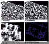 |
| The investigation of one of the central insulae of Wroxeter by four different methods. Centre left is a courtyard building, partly trenched by Kathleen Kenyon in 1953. |
This work in the countryside was matched by extensive work in the town of Wroxeter itself. This consisted of widespread geophysical prospecting — a strategy that received much publicity. Aerial photography in previous decades has suggested that the town was sparsely occupied: there were plenty of buildings in the central core, but the insulae just inside the walls appeared to be empty. At the same time, English Heritage, which has owned the monument since the 1970s was concerned to learn more about the site. The survey was made possible by the happy coincidence that Vince Gaffney, who was overseeing the project for BUFAU, has a brother, Chris, who is one of the directors of Geophysical Surveys of Bradford, one of the leading firms of commercial geophysical surveyors. Chris was keen to do some research work on the site and came down to Wroxeter to do a week of intensive magnetometry survey, a commitment matched by English Heritage's Ancient Monuments Laboratory. The results were of such extraordinary clarity that it was decided both to cover the whole of the town and to carry out some more experimental work. An important conference on geophysical prospecting was being held at Bradford, and several foreign teams were persuaded to come along and display their skills. Thus a French team carried out automated resistivity, a Japanese team showed off their ground-penetrating radar, a German researcher used a caesium magnetometer and a Canadian professor used seismic technology. Britain was represented by Roger Walker of Geoplot and the other more experimental techniques used by the Ancient Monuments Laboratory and Geophysical Surveys. In conjunction with these surveys, conventional twin-probe resistivity has been carried out by a team of volunteers from the project, which supplements the magnetometry results. The overall results have revolutionised our knowledge of Wroxeter.
Aerial photography's main drawback is that the remains it picks up are principally those of stone buildings, giving the impression that only the centre of the town was intensively occupied and leaving large open areas around the periphery. Geophysical surveys on the other hand reveal pits and evidence for industrial activity as well as the disturbance caused by more modest wooden buildings. This suggested that the former blank areas were in fact densely settled or were occupied by lower-status buildings, industrial activity and by clusters of pits. However a large blank area in the field just opposite the baths (today occupied by the village football field) is confirmed as being 'blank' and the archaeologists wonder whether this might not have been the cattle market — the forum boarium. A more sophisticated approach to the town is beginning to emerge.
The results are also being put to a more imaginative use. By taking the accurately referenced geophysical surveys and aerial photographs of the city, Sally Exon at BUFAU is reconstructing all Wroxeter's buildings in Virtual Reality. The development work is funded by BT and the results will be available on the web and as a CD-ROM. As a result, people will be able to visit Wroxeter and explore its buildings and streets in a way never attempted before, and we can perhaps then begin to understand this complex site and its surrounding countryside.
![]() For more information on the Wroxeter hinterland project, visit BUFAU's website.
For more information on the Wroxeter hinterland project, visit BUFAU's website.
| © Roger White 1998. This article was originally published in Current Archaeology 157 (May 1998). |
Thanks to Current Archaeology for permission to reproduce this article.